Day 1 :
Keynote Forum
Gualtiero A N Valeri
Santa Rita University of Rome, Italy
Keynote: The geophysical precursors of earthquakes: Emission of radon-222 and ionizing radiation in imminent earthquakes – The proposal of a seismic warning network for Ecuador
Time : 9:30-10:10

Biography:
Abstract:
The predictability of earthquakes is now object of contrasting opinions, for strictly scientific problems type (the difficulty to correlate closely certain precursors to the occurrence of the phenomenon in a certain interval of time, space and intensity) and social (the management of the reactions of the population in face of an alert which is difficult predict the duration and the real level of risk). However, new knowledge in the fields of nuclear physics, geophysics and geochemistry, together with the availability of new technologies that make it possible to accurately detect certain phenomena, have opened new perspectives to the opportunity to know, with sufficient precision, if or not will be an imminent earthquake, the epicentral area and its intensity. Based on these new principles, is already being tested, since 2001, first in Italy (No. 3 stations), after in Island of Taiwan (No. 4 stations) and now in California (No. 3 stations) a methodology using joint the analysis of 222Rn gas emissions from the Earth's crust, and the emissions of ionizing radiation from the Earth's surface via satellite systems. In the specific case of the Ecuadorian territory, always affected by seismic and volcanic phenomena, already today, for occurrences of volcanic eruptions and tsunamis, is operating an efficient system of managing these risks. In the case of Ecuador, would be placed No. 5 gamma detectors along the hinterland of the coast, at a distance therefore rather reduced from subsidence line between the Nazca and the South American plate, and in any case at a sufficient distance from active volcanoes, to prevent interference. Is therefore expected that is possible to study the response of the method in an area particularly affected by continuous and intense crustal movements, and where is monitored by other parameters that can be compared with the new exposed here
Keynote Forum
Sangseom Jeong
Yonsei University, Korea
Keynote: Wireless sensor network for monitoring and early warning system of landslides
Time : 10:10-10:50

Biography:
Sangseom Jeong is a Professor of Yonsei University, President of Korean Geotechnical Society (KGS), Vice President of TC212 (Deep foundations) in ISSMGE (International Society of Soil Mechanics and Geotechnical Engineering), Chair of Asian TC-18 (Mega Foundations) and President of GIT4CC center. He has authored and served as a reviewer for many geotechnical journals. He has co-edited 15 national geotechnical engineering text books and authored about 68 SCI articles in major reputable international journals, 132 national journals, 76 international conference papers, 80 technical consulting reports and 30 patents in deep and shallow foundations, excavation and slope stability
Abstract:
Landslides induced by heavy rainfall cause significant damages to civil infrastructure. A lot of methods and technologies have been proposed to detect the landslides and slope movements. There have been increasing interests in developing and landslide monitoring systems to observe movements using sensors installed on the slope. Wireless sensor networks (WSN) are a promising new in-situ measurement technology for large areas. This study describes the wireless sensor network system for landslide detection and early warning system at regional scale that is able to check the landslide condition real-time in the internet environment with monitoring data in connection with the field installed system. The system consists of a base station, nodes and sensors. Nodes are installed in a landslide hazard area to acquire data through sensors. The acquired data is transmitting the base station. The base station collects data from each node and provides it to the internet server. The sensors for detecting landslide are equipped with a tensio meter, soil moisture sensor, inclinometer, and rainfall gauge. In order to confirm the applicability, WSN was applied to actual mountain area in Seoul, Korea. As a result, the change of water content and matric suction due to rainfall could be measured at the watershed scale, and the most dangerous areas could be selected. The measurement data can be used as a landslide early warning system. It can also be used as initial input values or verification data of landslide analysis
Keynote Forum
Hesham Ali
Florida International University, USA
Keynote: Macro level analysis of sea level rise effect on pavements structural capacity
Time : 11:10-11:50

Biography:
Hesham Ali has 21 years of Civil Engineering experience, mostly in pavement design, analysis and construction. He published more than 30 papers and participated in the delivery of hundreds of roadway and airport construction projects in New York, Maryland, Pennsylvania, Texas, Virginia and Florida. He has 10 years of executive experience at FDOT where he participated in the delivery of $3 Billion of highway construction and maintenance projects. He holds a Master’s and PhD in Civil Engineering from The City University of New York. He has been involved in the technical development and promotion of pavement recycling.
Abstract:
The State of Florida maintains 40,000 lane-miles of paved roads. The design of such roads calls for a 3 foot clearance between the pavement base and the ground water table for multi-lane roads and a 2 foot clearance for rural 2-lane roads. The purpose of this clearance is twofold: First, allow for dry conditions during construction to facilitate placement and compaction of subgrade and base layers. Second, budget for a capillary rise of 24” and fluctuating ground water table and ensure dry subgrade conditions during the life of the road, which is essential for a good subgrade support, as characterized by the Subgrade Resilient Modulus. The objective of this effort is to quantify the effect of ground water table rise, caused by Seal Level Rise, on pavement structural capacity. Examine, at a network level, a set of strategies that can help with the SLR challenge over the next 30 years. It is envisioned that maps of roads be prepared on the basis of base-water clearance. Then use time forward projection of ground water table rise rates to determine the time frame in which FDOT would have to address the pavement deficiencies. Three scenarios will be considered for the rate of SLR; Low, Moderate and High.
|
SLR Scenario |
Low Rise |
Moderate Rise |
High Rise |
|
2016 |
X |
X |
X |
|
2020 |
X |
X |
X |
|
2030 |
X |
X |
X |
|
2050 |
X |
X |
X |
X GIS Map of Base-water Clearance.
GIS maps can be presented in terms of: The deficit in base-water clearance and; the deficit in structural capacity, as determined in equivalent single Axle load. For instance, as a result of the reduction in subgrade modulus, the remaining life of a pavement section can be computed in ESAL: Loss of vehicle miles traveled as a result of reduced capacity. This will be computed by converting the axle count into vehicles and multiplying by the mileage and; cost estimate of cost of increasing the pavement structural capacity so as to eliminate the structural deficiency.
- Geological Disasters and Earthquakes | Geographic Information & Remote Sensing | Disaster Risk Management | Alarming Alerts and Early Warning Systems
Location: Crystal
Chair
Sangseom Jeong
Yonsei University, Korea
Co-Chair
Hesham Ali
Florida International University, USA
Session Introduction
Rosa Lasaponara
University of Basilicata, Italy
Title: Remote sensing of forest fire
Time : 11:50-12:15

Biography:
Rosa Lasaponara is Senior Researcher of IMAA-CNR (Italian Research Council, Institute for Environmental Monitoring) since 2001. She is responsible for the ARGON laboratory (Earth Observation for ARchaeoloGy and EnvirONment). She serves as Professor of Microwave at University of Basilicata, Visiting Professor at RADI Beijing (2015-2016) and PI of numerous projects funded by ESA, ASI in the context H2020 and operational monitoring of forest fire Protezione Civile of Basilicata region. She has authored about 350 publications among papers in international journals, books, book chapters, papers in proceedings of international conferences on: Remote sensing for environmental monitoring, risk assessment, mitigation and modelling, time series analysis, Remote sensing for archaeology and environmental studies. Her dominant scientific interest focuses on: the operative use of EO techniques mainly in the fields of: i) fire risk monitoring ii) interactions between humans and environment systems; iii) Anthropology: mainly land use practices and their effects on ecosystems and; iv) innovative active and passive remote-sensed technology for environmental and landscape monitoring
Abstract:
Remote sensing can fruitfully support the operational monitoring of natural and manmade risks. This paper provides a short overview of satellite remote sensing for forest fires. Since the mid-1980s satellite remote sensing data have been used for forest fire monitoring for applications in the diverse phases of fire management as, for example, fire prevention, danger estimation, detection of active fires, estimation of fire effects (burned area mapping, fire severity estimation, smoke plumes, biomass losses, etc.), post fire recovery, fire regime characterization, etc. Fires are considered one of the most important causes of degradation being that they induce significant alterations not only on the vegetation cover but also on fauna, soil, and atmosphere producing high direct and indirect losses including economic ones. Fire affects vegetation, landscape and environment at short as well as long-term. Short term fires induce patch homogenization and create positive feedbacks in future fire susceptibility, fuel loading, fire spreading and intensity and facilitate alien plant invasion. Long term fires lead permanent changes in the composition of vegetation community, cause decrease in forests and loss of biodiversity, impact vegetation dynamics. Moreover, fires induce soil degradation, alteration of landscape patterns and ecosystem functioning, thus speeding desertification processes up. Fires are today recognized as a global social ecological problem with expected potential increasing trends also due to land abandonment and climate change. The contribution of remote sensing (RS) to forest fires may be grouped in three categories, according to the three phases of fire management: (i) risk estimation (before fire), (ii) detection (during fire) and (iii) assessment (after fire). Relating each of these phases, wide research activities have been conducted over the years. Today satellite technologies can fruitfully support both research and operational activities for investigations and monitoring of fire and fire effects at different temporal and spatial scales, with cost effective tools.
Mustafa Al-Shamali
Kuwait Institute for Scientific Research, Kuwait
Title: Seasonal color spectrophotometric variation of dust sample within Kuwait
Time : 12:15-12:40

Biography:
Mustafa Al-Shamali obtained a BA in Chemistry with Philosophy minor from Utah State University (USA) and Master’s degree in Chemistry from the University of York in Solid State NMR, BhD from PCU USA in Chemistry. He worked at the Central Analytical Laboratory at KISR from 2006 till 2014 and currently working at Petroleum Research Center in Kisr. His areas of expertise include spectroscopy techniques as FT-IR, FT-NIR, Floromax, UV-VIS and MNR. In addition, support instruments such as soxhlet extraction manual and automated, accelerated solvent extraction (ASE) and others. He is working on method development in food, nature and petroleum.
Abstract:
Kuwait is well known for its long-term occurring dust storms and the various color patterns that come along with them. Determining the spectrophotometric color variation of dust samples plays an important role in estimating the chemical and biological content of the dust in the dust collector. Dust content can have a negative effect on life species sometimes. In this study, an identity model was established for the dust collector during the various seasons of the year by near-infrared spectroscopy (NIR), while ultraviolet and visible region (UV-VIS) was used to find the maximum absorption for each color. The mid infrared was sediment color in Kuwait, but some were done on a regional-scale such as Al Ruba’, Al Khaali, and Al Dibdibba. Therefore, there is a certain need to start a much broader investigation regarding sediment color in Kuwait.
Wei Yang
Chiba University, Japan
Title: Monitoring water quality of inland lakes by remotely sensed observations
Time : 12:40-13:05

Biography:
Wei Yang received the BS and MS degrees in Physics and Civil Engineering, respectively, from Beijing Normal University, Beijing, China, in 2005 and 2008, respectively, and the PhD degree in Integrative Environmental Science from the University of Tsukuba, Tsukuba, Japan, in 2011. He is currently an Assistant Professor with Center for Environmental Remote Sensing, Chiba University, Japan. He has worked on satellite image fusion and the effect of topography to vegetation index. His research interests include quantitative remote sensing of inland waters and terrestrial vegetation, as well as forest structure modeling.
Abstract:
Accelerated eutrophication of inland waters is becoming a significant environmental issue all over the world. The sustainable management of freshwater ecosystems requires routine monitoring of water quality. However, the spatial and temporal heterogeneity of water bodies coupled often result in inadequate monitoring and characterization of water quality using conventional sampling methods. Remote sensing techniques are very useful for monitoring inland waters in terms of being able to cover large spatial areas at very frequent intervals. From the perspective of remote sensing, global waters can be classified into two types: Case 1 and case 2. Case 1 waters are those dominated by phytoplankton (e.g., open oceans), while case 2 waters are waters influenced not only by phytoplankton but also by other substances that vary independently of phytoplankton (e.g., some coastal and inland waters). The remote sensing of case 2 waters has been far less successful than that of case 1 waters, due mainly to the complex interactions among optically active substances in the former. In this presentation, I will introduce a series of remote sensing algorithms we proposed recently to estimate water quality parameters, including concentrations of chlorophyll-A, suspended solids and colored dissolved organic matters, as well as transparency and Euphotic zone depth. These algorithms have been widely validated using extensive field collected data sets, and can overcome the difficulties in remote sensing of highly turbid inland lakes. A case study on satellite-based operational monitoring of chlorophyll-A concentrations in a lake of Japan will also be presented. Evaluation results demonstrated that the proposed algorithms have the potential of being applied to operationally monitor water quality of inland lakes.
Young-Soo Han
Korea Institute of Geoscience and Mineral Resources, South Korea
Title: Interaction of Sb(III) under sulfide-rich reducing environment: Batch and spectroscopic investigations
Time : 14:05-14:30

Biography:
Young-Soo Han has received her BSc (2000) and MSc (2002) from University of Seoul in Environmental Engineering. She got her PhD degree (2009) and worked as a Post-doc in Civil and Environmental Engineering from University of Michigan-Ann Arbor, MI, USA. She also worked as a Post-doc for two years at the Earth Science Division in Lawrence Berkeley National Laboratory, CA, USA. She joined KIGAM in 2013. Her research interests focus on the geochemical behavior of toxic trace metals (particularly, arsenic) and organic contaminants under various redox conditions. Her research interests do not limited to the geochemistry, but she also has been working on the terrestrial soil carbon sequestration and microbial toxicity researches. On these topics, she is author or co-author of more than 20 scientific publications.
Abstract:
This study examined the reaction mechanism of antimonate Sb(III) uptake in iron monosulfide mackinawite and compared its removal capacity and pH-dependent uptake behavior with that of As(III). The comparison of Sb(III) with As(III), based on their chemical similarity, may give useful insight into the chemical properties of the less studied Sb(III). Batch sorption studies revealed that Sb(III) had a higher affinity for mackinawite at pH 5 than pH 7 or 9. While As(III) displayed a similar trend, there was a much higher uptake of Sb(III) under all three pH conditions. A spectroscopic study demonstrated the high uptake of Sb(III) at pH 5 was due to precipitation of the sulfide mineral Sb2S3 as a consequence of the mackinawite dissolution while the removal at pH 7 or 9 was inferred as a surface reaction possibly a sole or mixed reactions of adsorption and surface-precipitation. These pH-dependent Sb(III) uptake mechanisms are similar to the corresponding mechanisms for As(III) uptake, demonstrating that mackinawite is also a good scavenger for Sb(III) in ferrous and sulfide-rich reducing environment like for As(III).
Image
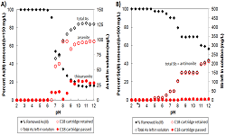
Figure 1: As(III) and Sb(III) removal efficiency under pH 2 to 12 with the amount of dissolved As or Sb left in solution with its speciation (I0 = 150 mg/L for As(III) and 500 mg/L for Sb(III)). Aqueous speciation was conducted using Bond Elut C18 cartridge
Rowena R Sazon
Ramon Magsaysay Technological University, Philippines
Title: Water quality in relation to phytoplankton abundance and density of mining-impacted river in Zambales, Central Luzon, Philippines
Time : 14:30-14:55

Biography:
Rowena R Sazon has completed her graduation (Bachelor of Science) in Biology (Microbiology) from the University of the Philippines Los Baá¹…os in 1990. She finished her Master of Environment and Natural Resources Management from the UP Open University in 2004. In 2009, she graduated with Great Distinction from the Faculty of Bioscience Engineering at Ghent University (Universiteit Gent), Belgium for her second Master’s degree, MS Environmental Sanitation (Water). Her research focused on ex-situ bioremediation of oil-polluted clay soils. Her research interests include phytoremediation and water and sediment quality evaluation. She finished PhD in Environmental Science at the School of Environmental Science and Management in UPLB under the DOST-ASTHRDP Scholarship Grant where she worked on the assessment of the environmental impacts of mining operations in the riverine ecosystem. She is currently serving as Associate Professor III at the Department of Biology, College of Arts and Sciences, Ramon Magsaysay Technological University (RMTU) in Zambales, Philippines
Abstract:
The Philippines ranked fifth in terms of mineral resources with Zambales as one of the declared reservation sites. Open pit mining method employed in nickel extraction within the watershed resulted to removal of vegetation triggering soil erosion, runoff and sedimentation. After years of operation, environmental issues related to water and soil quality arose due to continuous silt deposition in water bodies and flood plains. The aim of the study is to assess the water quality and plankton community structure of a river impacted by mining operations in Zambales to aid the decision makers in the formulation of rehabilitation measures and strategies for restoration and sound utilization of its water resources. Seasonal changes in water quality were evaluated at four sampling stations in terms of physico-chemical characteristics which include temperature, pH, dissolved oxygen, electrical conductivity, salinity, total dissolved solids, Secchi disk visibility, chemical oxygen demand, nitrate-N and phosphate. Phytoplankton were identified up to the lowest possible level and their density and abundance were correlated with water quality parameters. DO, total dissolved solids and COD exceeded the Department of Environment and Natural Resources limit for Class C water. Nitrate and phosphate content indicates oligotrophic status of the river except after flooding brought about by typhoon Koppu where phosphate exceeded the limit of 0.2 mg/L. About 38 taxa of phytoplankton belonging to five taxonomic groups were identified and the predominant species are those that thrive in oligotrophic condition and high organic pollution. Correlation existed in some water quality parameters and phytoplankton density and abundance. The river is no longer in healthy state as indicated by its high COD and low DO suggesting an urgent need for river rehabilitation so as to abate their negative consequences not only to aquatic life but also to the livelihood sources of the fishery and farming sectors.
John K Buor
Ghana Institute of Management and Public Administration, Ghana
Title: Effect of frequent policy change on disaster preparedness and systemic resilience
Time : 14:55-15:20

Biography:
Abstract
Statement of the Problem: Reducing exposure to hazards, lessening vulnerability of people and property, wise management of land and the environment, early warning, and improving preparedness for adverse events are all pre-requisites leading to disaster risk reduction. However, it appears that key industry players and stakeholders are not able to anticipate the effects of strategic risk management decisions. Blindfolded by cost management tendencies, supplies of resources leading to disaster risk reductions have kept dwindling over the years.
Methodology & Theoretical Orientation: We employ system dynamics (SD) modelling, with data sourced from elitist interviews, to analyse the structural behaviour of the interactions between Disaster Preparedness, Systemic Physics (or the physical environment), and Systemic Resilience in response to policy change in maritime logistics setting.
Findings: Results from our research suggests that frequent policy interventions geared towards disaster reduction has the potential to produce unintended consequences as levels of increased unacknowledged conditions.
Conclusion & Significance: Our research models therefore, could provide strategic policy makers with real-time decision evaluation tool to justify the choice of a set of alternative risk reduction interventions prior to decision implementation.
Abstract:
John K Buor is developing expertise in his research into effects of policy change on logistics/supply chain risk, security, emergency, and disaster/disruption management leading to uninterrupted flows in global logistics (i.e. hazard management and disaster preparedness). His research philosophy is founded on Giddens’ (1979) theory of structuration. He employs hybrid methodological approach (system dynamics simulation modelling techniques) to model the potential consequences of policy interventions on the structural behaviour of the interdependencies between/among factors that can influence global logistics/supply chain resilience and sustainability with a keen interest in promoting green logistics/supply chain and environmental safety
Fantonalgo Raymund N
University of the East-Manila, Philippines
Title: Cell density and chlorophyll a content of Navicula sp. exposed to the different concentrations of pesticide cypermethrin
Time : 15:20-15:45

Biography:
Fantonalgo Raymund N served as a Faculty of Natural Sciences, Senior High School Department, College of Education, University of the East-Manila, C M Recto Avenue, Manila, Philippines. His areas of specialization include Ecotoxicology, Algal Natural Products, Phycology, Environmental Issues and Concerns.
Abstract:
Diatoms are considered as the major primary producers in the ocean. Most of the times, these organisms are affected by materials from river run-offs. In this study, the effect of cypermethrin to the cell density and chlorophyll A (chl A) content of Navicula sp. was evaluated. This investigation employed Randomized Complete Block Design (RCBD) as an experimental design with five treatments. Treatment (T1) (negative control) did not receive experimental pesticide. Treatment two (T2), treatment three (T3) and treatment four (T4) were treated as experimental groups. Two millimeters, one millimeters, and half millimeters were introduced to T2, T3 and T4 respectively in order to come up with 32 mg/L, 16 mg/L, and 8 mg/L respectively. Treatment five (T5) (positive control) received 4.7 mL (328 mg/L) of Chlorpyrifos (Brodan). The chl A content of the diatom was evaluated during spectrometric method and its cell density was determined using the hemacytometer during fourth day of culture. Findings indicated that the chl A and cell density of Naviculasp in experimental treatments and the positive control (Chlorpyrifos) were statistically the same, however; there was significant difference compared to the negative control (distilled water). The reduction in cell density and chl A content was brought by ability of the pesticide to destroy the cell structure of the diatom. Since cypermethrin showed significant reduction in chlacontent and cell density of diatom Navicula sp., proper and careful use of this chemical should be observed in order to prevent from creating harm among the aquatic organisms.
Rozita Farzam
University of Tehran , Iran
Title: Study and design of Gensai products: Reducing the amount of damage after natural disasters- The case study of creative ideas of Iranian and Japanese students
Time : 16:00-16:25

Biography:
Rozita Farzam is working as Assistant Professor from October 2014 to till date and an Academic & Faculty Member at Industrial Design Department, University of Tehran, College of Fine Arts. Tehran, Iran. She completed her Master’s and PhD from the Department of Environment Design at Kobe Design University, Kobe, Japan. In September 2013, she published her doctoral thesis; Titled “A Study on Day Lighting Systems for Iranian Schools- Design Process of Integrated Lighting Systems for Existing Classrooms”, Kobe Design University, Kobe, Japan. She is associates between University of tehran with Universities of Japan.
Abstract:
Natural disasters, which are a part of human life process has increased in its number and diversity every day and is raised as a major challenge to achieve sustainable development of human societies. Iran is considered as one of ten accident-prone countries in the world due to its geographical and geological location. So for years, the strategies such as crisis management, education, architectural design and others have been considered to reduce the impact of natural disasters on the country. Hence, the need for investigating the product design is important from the stage of risk identification to emergency response and natural disasters recovery. The aim of this study was to investigate strategies to design products focused on minimizing the damage rate caused by natural disasters as well as to assess the ideas against these terrible disasters. Since Japan is the founder of this topic and has designed multiple products in coping with natural disasters, therefore, the workshops held in this regard in Japan and a similar one in Iran holding by the authors, have been selected as the case study. This study which was based on cross-sectional approach evaluated in order to fulfill the goals through the study of documents, books, essays and articles as well as holding workshops and analyzing the projects; and ultimately, some suggestions are presented by conducting the hierarchical analysis. Our results show that designing the products by Gensai approach plays a significant role in reducing the damages of natural disasters.
Lorenz J Fajardo
Central Luzon State University, Philippines
Title: Fluctuating asymmetry in morphometric and meristic traits of white goby (Glossogobius giuris Hamilton, 1822) as indicator of stress in the east bay of Laguna lake, Philippines
Time : 16:25-16:50

Biography:
Lorenz J Fajardo is an Assistant Professor at the College of Fisheries, Central Luzon State University (CLSU), Philippines and a registered Fisheries Technologist. She took BS in Fisheries in CLSU through the Bureau of Fisheries and Aquatic Resources scholarship and graduated in 2002 as cum laude. She pursued MS in Aquaculture at Ghent University, Belgium under the Flemish Interuniversity Council Development Cooperation (VLIR-UOS) and received the degree with distinction in 2009. Her opportunity to pursue Doctor of Philosophy in Environmental Science at the School of Environmental Science and Management, University of the Philippines Los Baños was made possible through the Accelerated Science and Technology Human Resource Development Program of the Department of Science and Technology, Science Education Institute. She just finished her PhD last January 2017. Her research interests include aquatic ecology and biodiversity, limnology, biomarkers and bioindicators in aquatic ecosystems, microalgal culture and biotechnology, and environmental security and management.
Abstract:
Laguna lake, the largest freshwater lake in the Philippines, has been threatened by fertilizer and pesticides runoff from agricultural land uses in the eastern bay. Glossogobius giuris is one of the native and commercially important fishes in the lake and is reported to be of declining population. The sensitivity of fish to the health of surrounding aquatic environments offers the possibility to obtain an ecological overview of the current status of aquatic ecosystems. Fluctuating asymmetry (FA), the small, random differences between the left and right sides of bilaterally symmetrical organism, is a simple, less invasive and cost-effective tool in monitoring environmental stress. This study determined FA in 17 morphometric and meristic traits of G. giuris populations from two agricultural sites (wild) and rearing tank (reference). It was found that more traits of wild populations exhibited FA. Detected FA on caudal peduncle depth and opercular length in the reference population could be attributed to the lack of ecological requirements in the captive condition. The FA level of caudal peduncle depth was significantly higher in the wild while of pectoral fin ray was not significantly different (P>0.05) among populations. Composite fluctuating asymmetry (CFA) analysis revealed highly significant difference (P<0.01) among populations although mean values showed higher CFA level in wild. Higher FA levels could indicate the more disturbed developmental homeostasis or decreased developmental stability in the face of stressors and to perceive changes in the surrounding environment. Findings may indicate the contributory effects of environmental conditions associated with anthropogenic pressure particularly on pesticide application on the developmental stability of gobies in the lake. Future researches should consider investigating the effect of different stressors on G. giuris populations from the other bays and tributaries of Laguna lake to have an overall assessment on the status of this fishery resource.
Choon Yong Heng
Curtin University, Australia
Title: Doomsday rehearsal: Architecture for pre-disaster learning and 2020 Tokyo Olympics the year of disaster prevention global classroom Choon Yong Heng
Time : 16:50-17:15

Biography:
Choon Yong Heng is an Architecture Enthusiast and young Architecture Graduate from the Curtin University (2017) and currently practicing at Hassell Studio, Perth. He believes that great architecture makes impactful experiences, even shapes user’s behavior on and off from the daily context. He always looks to participate in conversations on community and environmental series. His Master’s thesis expressed his concern about catastrophic contingencies reaction in the crowd. He is looking forward in more extensive research and have the intention to deliver a communication package before the year of 2020 for the Japan Department of Risk Management and Tokyo Olympics Organization Committee.
Abstract:
Statement of the Problem: Natural disaster raises awareness in contemporary capability of reacting contingencies. Japan is one most hazardous place due to its geological context. Research looked into Japanese disaster prevention culture, risk management experience and the integrity of disaster prevention facilities. Research found that Japan is successful in managing risk because of their pre-delivery of the BOUSAI disaster safety code; knowledge that reaching public consensus so that their citizens have less contradictory decisions when dealing contingencies. However, disaster prevention architecture still performs in a conventional approach. Research has aligned two strategies, BOUSAI Disaster Prevention and Tokyo Olympic Urban Development & Planning Guide. The purpose of this is to examine the feasibility of adopting education and experiential architecture in disaster prevention use.
Methodology & Theoretical Orientation: Research mapping, visual diagrams, and architectural composite drawings are utilized to conduct the design ideas. Researcher has foreseen the architectural capability to deliver great user experience in DRR strategy and utilized 2020 Olympic year as the opportunity to disseminate the BOUSAI disaster prevention ideology. Architecture is the medium to translate this prestige knowledge and introduce to the international audiences.
Outcome: The visual package has leaded the conversation of aligning Tokyo Olympic with BOUSAI to discuss over five key aspects of this alignment. It is BOUSAI re-introduction, DRR research core, immersive simulations, post-disaster living scheme, and future method of natural preservation. Researcher demonstrates BOUSAI in the transformation from written intellectual to spatial experiences. Comparative images and diagram will also be provided to show the degree of architecture contribution.
Conclusion & Significance: Disaster simulations and pre-disaster rehearse could strategically succeed in reducing disaster risk. Research expect that Tokyo Olympic is in another way to take disaster prevention education into a deeper level and globalize disaster prevention research collaboration. It also fulfills the scheme of a sustainable Post-Olympics strategy.